LOST VILLAGE OF BOLD, TRAQUAIR PARISH, PEEBLESSHIRE, SCOTLAND.
The site of the village of Bold can be found on the south bank of the River Tweed just east of the town of Walkerburn - co-ordinates NT3636. According to maps - see the Lost Village of Bold section of the Picture Gallery - Link at foot of page - the earliest map of 1741 shows the village straddling the Bold Burn. However subsequent maps show the village on the east side of the burn. Was 1741 when the village was at its zenith? For a time it was named east Bold as an extension of the village westwards was named West Bold - the approximate location of the present day farm house of that name. The name is spelt in various other ways in the records and maps viz. Boll, Bole, Boale etc. The name survives to the present day with the Bold Burn, West Bold Farmhouse, and the topographical features of Boldrig and Boldhope. The latter being adjacent to the Minchmore Road – now part of the long distance footpath the Southern Upland Way. The site of the village of Bold is in the Tweed Valley Forest Park and is populated with Forestry Commission housing and workshops and is known as Glenbenna.
My interest in the village of Bold stems from the fact that my Hope ancestors are recorded there in the seventeenth/eighteenth centuries. Some of these were weavers - there was a John Hope the father of William Hope who was recorded as a weaver in Bold - see the record of the birth of William Hope 06-07-1788 in the Picture Gallery. There were quite a number of Hope family lines in other Traquair Parish villages. My family were there in the eighteenth century but would appear to have dispersed during the latter part of the eighteenth and early part of the nineteenth century. By the first Census in 1841 and the commencement of the Statutory Records in 1855 they have more or less vanished from the Traquair Parish records. The name of the village of Bold also disappears from the Traquair records.
Examination of the 1851 Census for Innerleithen shows five Hope families of which three, possibly four, had their origins in Bold. This indicates that there was a probable migration to Innerleithen as part of the Industrial Revolution with water powered woolen mills being constructed on the Tweed and its tributaries. Innerleithen was one of the first with the Caerlee Mill c1790. This migration would include the Hope families and other families residing in nearby small villages such as Bold. However not everybody went to the mills as there would also appear to be an increase in agriculture with farms expanding including that at West Bold. Hence the migration is probably mainly the result of urbanisation caused by the Industrial Revolution but also as the result in the increase in agriculture due to the Agricultural Revolution and possibly also connected with The Lowland Clearances.
The completeness of the migration resulting in a village such as Bold, disappearing completely is astonishing. The name itself only survives because of the farm house named West Bold. However it would appear that other Traquair Parish villages suffered the same fate – two others are Tanielburn and Fethane1. The site of the latter is still visible3. All three were quite populace but I think that Bold was the largest and was the first to disappear.
The Statistical Account of 1791/99 for Traquair Parish lists the village of Bold along with several villages. However the 1834/45 Statistical Account reveals that “in this Parish there is scarcely any thing deserving the name of a village. Excepting about twenty families of trades-men and labourers, several of whom are bound to “bondages” for their houses, the population is wholly rural, and live around the farm steadings to which they are respectively attached.”
The populace village of Bold by the 1841 census had been reduced to only one dwelling with five occupants. However the farm of West Bold had twentytwo occupants spread over five residences. By the 1851 census there was now nobody at Bold but at West Bold farmhouse there was thirtythree residents all occupied in agriculture. Attached Map No 6 of 1855/1882 very effectively shows the extent of the West Bold Farm compared to the site of the village of Bold which was adjacent to the Bold burn a few hundred yards east of the farm.
The first time that Bold is mentioned in the records was in 1296 when William of Bolhope took up personal arms against King Edward Ist, refused to submit to Edward and was summarily executed 2. I believe that Bolhope here is the Boldhope in Traquair Parish. Bolhope was thus adjacent to the Minchmore Road and deep in the Ettrick Forrest.
John of Bolden4 is recorded in the early fifteenth century followed by the Cranstons of Bold4. In 1510 a letter of licence was issued to William Ker of "the Yair" to sell six husbandlands of Bold, in Peeblesshire , to james Stewart, James Sandilands, William Murray and others. Next were the Cranstons of Bold. The first Cranson being Hector Cranston 1st of Bold in 1526 through a total of five generations to John Cranston 5th of Bold alive 1630. There is a family of Lowis at Plora4 referred to in 1626, 1690, 1704 and 1708-24.
The probable site of the residence of the Cranstons and more definitely of the family of Lowis is the site recorded by The Royal Commission on the Ancient and Historical Monuments of Scotland (RCAHMS) as Tower, Plora Burn 3. This site also appears on several of the old maps as Plora. Edgar's map shows a boundary line near Plora that would to indicate that Plora was outwith Traquair Parish but was within the parish of Yarrow in Selkirkshire.
There were other owners of the lands of Bold after the Cranstons but the lands eventually came under the Earls of Traquair.
According to Black5 the Scottish surname of Bold is derived from the name of the village in Traquair Parish, Peeblesshire. Is is probable that one of the many lines of the surname of Hope also originates here.
Mostyn John Armstrong6 writing in 1775 in his Companion to the Map of the County of Peebles stated that Bold is a populace village, near which is a standing cross. An attempt is now making, to sink a lead mine above Bold; an undertaking which, if crowned with success, will be a valuable acquisition to it's worthy proprietor, and a happy source of wealth to the country. What happened to the standing stone cross?
In 1817 James Hogg7- The Ettrick Shepherd - published the 1685 Covenanting story The Brownie of Bodsbeck. In this story the village of Bold gets a mention - On the very day previous to that, the Earl of Traquair had complained, in company with Clavers and his officers, of a tenant in a place called Bold, who would neither cultivate his farm nor give it up ---leading to the tenant being shot by Captain Bruce and his dragoons. The tenant is unnamed. This incident was probably handed down to Hogg by oral tradition.
In Robert Renwicks's Historical Notes on Peeblesshire Localities 8 it is stated in a footnote quoting A Guide to Innerleithen and Traquair published by R. Smail in 1867 (Full title of the Smail publication was Innerleithen & Traquair, past and present; with an angler's guide to the Tweed and its tributaries.) that even as late as 1775 - a populous village of Bold containing a number of weavers and other craftsmen. These handloom weavers mentioned by Smail would make the population of Bold and similar villages to be in demand in order to be retrained to operate the power looms of the new mills.
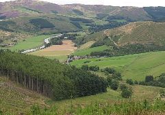
Photograph c Copyright Richard Webb and licensed under the Creative Commons Licence.
Glenbenna – site of the village of Bold. The cluster of houses in centre of picture is the present day Forestry Commission Village .
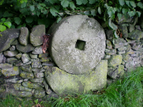
Photograph by Anthony J. B. Hope
Mill Stones set in to the dry stone wall at entrance to West Bold farm with the farm name, West Bold, incised into the lower stone which is a segment of the original outer mill stone. It is possible the mill stones came from the original Mill in Bold shown on old maps and records.
Attachments.
1 Entry in the Traquair Parish records for William Hope born 06-07-1788 in Bold
The following attached series of maps show the village of Bold in it’s prime and also the decline.
Attachment No 1 above and these maps can be viewed in the Lost Village of Bold section of the Picture Gallery
1 – Portion of Edgar’s map of 1741.
2 – Portion of Herman Moll’s map of The Ettrick Forest of 1745.
3 – Portion of John Ainslie’s map of Selkirkshire of 1773.
4. Portion of Armstrong Map of 1775
5 – Portion of John Thomson’s Atlas of Scotland of 1832.
6 - Portion of Ordnance Survey 25” 1855/1882.
References.
1. Russell, Olive M.W. Editor, At the Sign of the Cleikum, 1996, Bordersprint, Selkirk. ISBN 1 8986 5404 2.
2. Bain, Joseph. Calendar 0f Documents relating to Scotland, Vol IV, AD 1357-1509 and Addenda 1221-1435, 1881, H.M. General Register House, Edinburgh.
3. RCAHMS Inventory for Peeblesshire 1967 – Traquair Parish - Tower, Plora Burn 524 - Canmore ID 53101-Fethane (site) 678.
4. Buchan, J. W. History of Peeblesshire, 1925, Jackson, Wylie & Co, Glasgow.
5. Black, George, F. The Surnames of Scotland, 1999, Birlinn, Edinburgh
6. Armstrong, Mostyn John, A Companion to the Map of the County of Peebles, 1775, W. Creech, Edinburgh.
7. Hogg James, The Ettrick Shepherd Tales, 1886, Hamilton, Adams & Co, London
8. Renwick, Robert. Historical Notes on Peeblesshire Localities, 1897, Watson & Smyth, Peebles. (Renwick is quoting from a publication Guide to Innerleithen and Traquair published in 1867 by R. Smail the Printers of Innerleithen.)
Issue 3. Mar 2013.
___________________________________________________________________